Hiking the Inca Trail in Peru to Machu Picchu
posted on August 1st, 2008 in Andes Mountains, Incas, Machu Picchu, The Inca Trail
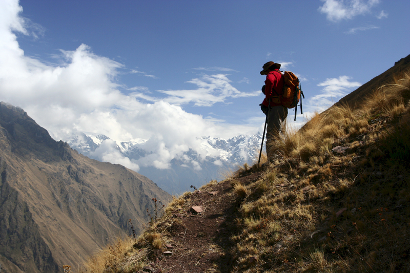
A hiker on the Inca Trail, Peru
(Note: the best advice I can offer readers for hiking the Inca trail is to book as early as possible–six months would be ideal–wear good shoes, be in good shape, and arrive in the Cuzco area as many days as possible to acclimatise yourself to the altitude. A week in the Andes before heading off is best and the better the shape you are in, the more you will enjoy the hike. By early March, 2008 the trail was booked through the entire summer–KM).
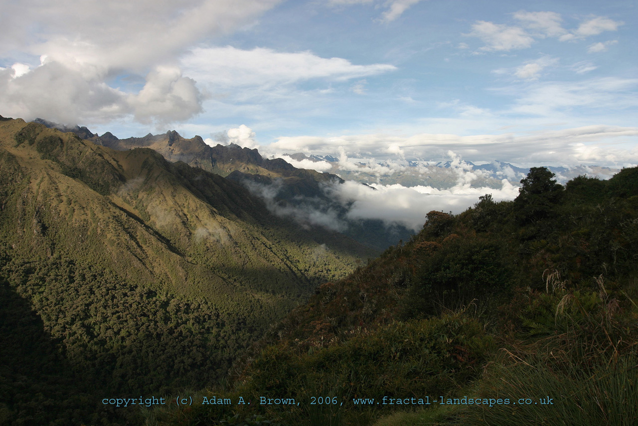
On the Inca Trail, Peru
Detroit Free Press
March 9, 2008
It can no longer be helped. The wetness creeps into my eyes like the condensation that shrouded our tent this morning…
Deep in the Peruvian Andes, several hundred yards from where I stand, a lump of mountain known as Waynupicchu shoots up like an inverted elbow. At its base lie perfectly carved stone triangles, parts of temples on terraces built by the legendary Incas.
It all looks like the classic pictures I had gazed at so many times in tour books and childhood encyclopedias.
It all looks flawless.
As wisps of clouds waft over the storied site, the exhilarating suffering of the past four days hurtles at me, inciting the tears, and this, its ultimate reward, becomes real.
I have made it, on foot, to Machu Picchu.
I have made it, indeed, but I have made it hobbling.
When I walk, I look nothing like the tourists who start coming off buses two hours later, fresh from a hotel room in Aguas Calientes or Cusco (also known as Cuzco). Unlike them, I limp, leaning desperately on a metal walking pole. And I probably smell much worse, too.
Hiking is a masochistic way to reach Machu Picchu, especially if the last time you remember hiking you were a 9-year-old at summer camp. Taking the bus up a series of switchbacks is a fine way to see the historic site, which after a global vote, was chosen in July as one of the New Seven Wonders of the World.
But there is something unparalleled about traversing the 30-kilometer (18.6-mile) classic Inca Trail to the most sacred site of an extraordinary civilization.
Aside from the stone palaces and fortresses and temples to inspect along the way (impossible to access by bus or train), there arises a profound respect for the people who built such buildings, blending them with nature, laying a pathway of stones for miles and miles.
I have barely made it over the up-and-down terrain in hiking boots. The Incas ran it in sandals.
Actually, I barely made it at all.
To get to the start of the classic Inca Trail route, at the 82-kilometer marker, almost everyone has to pass through Cusco, the one-time capital of the Incas and now a sprawling city, home to thousands of their descendants.
To get to Cusco, almost all international travelers must pass through Lima, the capital of Peru. That means going from about 350 feet above sea level to more than 10,000 feet. The highest point of the classic Inca Trail hike is at 13,826 feet.
It makes sense, then, that the recommended stay in Cusco before embarking on the trail is three to seven days, to let your body adapt to the altitude.
I had allowed just one day.
And then, because of a freak snowstorm in Chicago, I had no days.
This was not only unkind to my lungs. It put my entire vision of following the footsteps of the Incas in jeopardy.
You see, in the last few years, getting on the Inca Trail became about as easy as qualifying for the Boston Marathon. In the past, thousands more could traverse the trail, but when the Peruvian government realized the pathway was starting to deteriorate into a highway of trash and erosion from overuse, it limited the number of tourists who could hike on the trail to 200 each day.
If I didn’t start on the specific day for which I had a permit, I wasn’t going at all. Permits had been claimed for the next five months.
Fortunately for me, you cannot travel the trail alone. You must go with a group that has a licensed guide. I chose SAS Travel Peru, which departs on the four-day classic trail daily, and after several international phone calls, it arranged for me to take a taxi (the others had taken a bus) to the 82-kilometer marker start.
When I step out of the airport in Cusco, the altitude makes my lungs feel like balloons that refuse to inflate.
I feel better as I chat with Jose, my taxi driver, and then even better after I doze off. When I awake, Jose has already driven deep into el valle sagrado, the Sacred Valley, fertile with Incan sites .
When I arrive at Km 82, I find the other members of my group – from New Zealand, Australia, Canada, Malta and the United States. Half have quit their jobs so they can travel the world. We are all in our mid-20s.
Our guides, Saul Palma and Gilberth Laurel, split up so one always hikes in front and one behind, assuring us we will not go wandering off, dazed and lost in the Andes Mountains.
A large wooden sign we approach reads “Camino Inka-Inka Trail” – a mesh of Quechua (the language of the Incas), Spanish and English – and gives the start of the trail a kind of official feel. We are also processed through a small checkpoint hut where we have our passports stamped with “Control Piskakucho.”
To reach the trail, we cross a bridge suspended over the rolling Urubamba River, the lifeline of the Incas. The river’s sweeping current and the mountains that rise around gives a glimpse of the enormity of the hike.
And a picture of its beauty.
The hike, especially in the beginning, feels serene and not at all isolated.
Every few tenths of a mile, we stop to let locals walk past with their donkeys. Several times, we stop for trotting mares and curious roosters. Once, we stop for a pig.
Within an hour of setting out, we spot Inca ruins. Even from several hundred yards away, the walls reveal sturdy and meticulous design. As a friendly rain falls, we reach the pre-Incan fort and village of Willkaraqay. Here we can actually touch the ancient stonework and peek through the windows.
The fort offers a stunning look at Llaqtapata, a major Incan town with step terraces for farming. A temple called Pulpituyoc with rounded walls matches the curve of its perch next to the Urubamba River, which slithers below like a white python.
You cannot hike the Inca Trail without being amazed by the porters, whom Saul requested we call chaskis, the name for Incan messengers. There are about two chaskis for every one of us. Each day, they carry the bulk of what we didn’t want to tote, which usually means their load grows heavier as our legs grow sorer.
Always, the chaskis set up a tent for breakfast, lunch, dinner and snacks and our two-person tents for sleeping. Always, they cook – scrumptious foods like pumpkin soup, avocados and chicken. In the mornings, they wake us with tea brewed from coca leaves.
Used by Incan nobility, coca leaves act as a remedy for altitude sickness and a stimulant, but because cocaine is extracted from them, don’t pack them in your suitcase to take across the U.S. border.
As mornings begin between 4 and 5:30 a.m., coca tea becomes an ideal and necessary substitute for Starbucks mochas. It’s pleasant to drink it at dawn with my tent unzipped, watching pink light peek through the mountains.
The most brutal day is the second, when we climb 4,000 feet in four hours to reach Warmiwanuska, or Dead Woman’s Pass, which is how I feel. There is no denying soreness at this point, when the walking stick has become my third leg. By the third day, we no longer walk on dirt but on actual stones laid by the Incas.
Though it feels like trekking on an ancient Stairmaster, the constant ascents and descents never fail to reveal a spectacular view or a breathtaking Incan site. There is Runkuraqay, a watchtower shaped like a half moon. There is Sayaqmarka, whose many windows you sit in for a rest, and the intricate ruins of Phuyupatamarka, which has more curves than a Grand Prix track.
Rows upon rows of terraces used for agriculture rise up at Intipata and surround the majestic triangular-shaped walls of Winaywayna, or what our guide Saul calls “the most beautiful Inca site.”
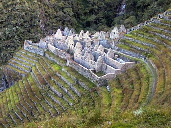
The Ruins of Winaywayna, along the Inca Trail
The stones lead us all the way to the Intipunku, the sun gate, which we power hike to on the fourth morning, in time to see the sun rising and shedding its first rays on Machu Picchu.
Sweaty and delighted, I teeter toward Machu Picchu, or “old peak,” avoiding two tan-and-white llamas that nearly slam into me along the way.
And then, 30 kilometers after I started walking, I am there, arriving at a place built in about 1450 by a meticulous, extraordinary people. The Incas would abandon it less than 100 years later, when smallpox and weapons from the Spaniards were ravaging their empire.
But the Spanish never found this city in the clouds.
It wasn’t until 1911 that a foreigner, American explorer Hiram Bingham, who had the help of locals, first came upon the site while hiking.
Of course, I, too, find it on foot – weary and amazed and still standing.
IF YOU GO
• Best times: The rainy season is just ending in April and the demand for permits hasn’t peaked in May, so those are two great months to go. September and October are ideal, too, because the rainy season will not have started yet. Competition for permits is highest June-August. The trail is closed in February for maintenance.
• Permits: you will not get on the Inca Trail if you do not have a permit, and you likely will not get a permit if you do not book well ahead. If you’re planning to hike in June, July or August, book your trip at least three to six months in advance. If you want to hike in other months, allow at least one to two months. Because you must go with a licensed guide, you will be booking your trip through a tour operator like Cusco Explorer www.incapoint.com
Check permit availability directly through Cusco Explorer www.incapoint.com
• Cost: Cusco Explorer offers a 4-day, 3-night hike known as the Classic Inca Trail for $ 290. The price covers three meals a day plus snacks, a sleeping tent, a sleeping bag and trail fees.
Roundtrip shuttle flights from Lima to Cusco range from $50-$150.
INCA TRAIL BASICS
• Fitness: You should be able to perform 30 to 45 minutes of cardiovascular exercise (walking, jogging, or biking) four to five days a week. Because of the constant ascents and descents on the trail, it would be optimal to incorporate some hills into your runs and walks or work out on a Stairmaster.
• Packing: The trail can get quite hot (80 degrees or more) during the day and quite cool (40 degrees or less) at night, so be sure to pack for a variety of temperatures. Hiking boots are ideal, as is a walking pole with a rubber tip. If you’re worried about hauling your backpack, you can hire a chaski (porter) starting for about $45 for the trip. Don’t feel like a wimp if you do; 13 of the 14 in my group did.
• Alternative trails: Several tour operators also offer a two-day hike on the Inca Trail, as well as other routes to Machu Picchu that, though not as storied, are just as beautiful. For a sampling, check out the offerings from Cusco Explorer www.incapoint.com
• Permits
To get a permit for the Inca Trail, the national park service requires the hiker’s passport information and a non-refundable deposit. The permits are issued for a specific person on a specific date at a specific point on the Inca Trail. Once purchased, these permits are not transferable or changeable in any way.
There are a number of alternative treks in the Cusco area that are not as famous as the Inca Trail, but are in many ways much more interesting and beautiful.
The Quechua Villages and Inca Ruins Trek takes you through the rural countryside from Cusco to Ollantaytambo through the villages of Parpishu, Chilipahua, and Peroniyoc. You will not see other tourists on this trek, but you will have the opportunity to interact with the local people as well as magnificent views of the surrounding mountains. This trek is finished off with two days at Machu Picchu including tour and overnight in Aguas Calientes — either with a day hike on the Inca Trail through the Sun Gate or via the train.
(Up Next: An Interview with Paolo Greer, Part 2)
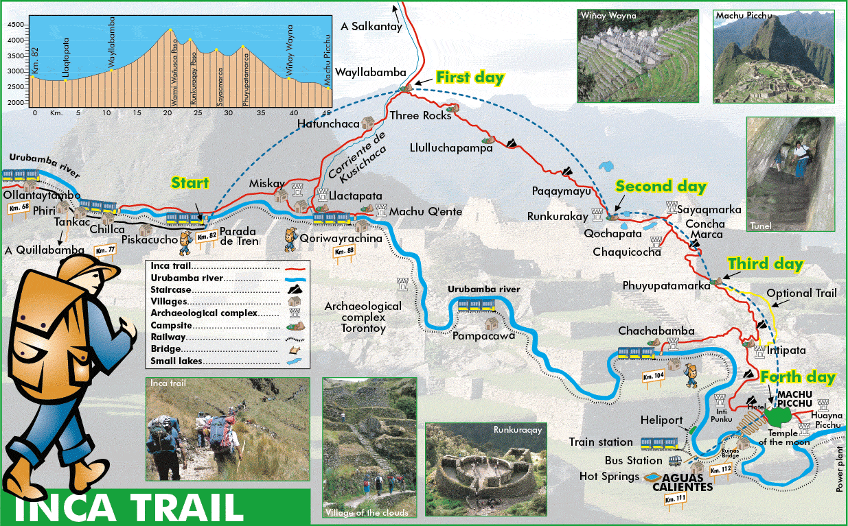
Map of the Inca Trail With Elevations